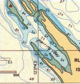
Portion of Chart 3313 (1995) courtesy of Canadian Hydrographic Service (disclaimer)
Portion of Chart 3313 (1995) courtesy of
Canadian Hydrographic Service
(disclaimer)
Dive Waypoint: 49D05.00N 123D43.00W
Anchorage Waypoint: 49D05.09N 123D43.00W
Skill Level: Novice
Depth Profile:Drops sharply to about 30 metres.
Facilities:Camping, water, toilets in Pirates Cove on De Courcy Island.
Hazards:Boats traversing Ruxton Passage.
Comments: Positions are from chart 3313. Sheltered anchorage available in Herring Bay; camping in nearby Pirates Cove Marine Park.
Rating: *** (One star - poor, 5 stars - excellent)
Entered by Andrew![[Problems?]](/maint/bugs.png)